District Profile
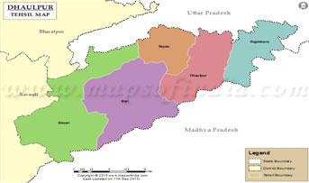
Dholpur is situated in eastern part of Rajasthan, located at 26 42’0” North latitude, and 77 54’ 0” East Longitude which comes under eastern flood prone zone with scanty and erratic rainfall. The district plays a vital role in the domestic economy of the state. This district covers as total area of 300913 ha comprising 0.90% of the total area of state. It is surrounded by Agra district of UP in the North, East, Morena district of M.P. in the South East and Koroli district of Rajasthan in West.
The district is divided in to 5 sub divisions (Dholpur, Rajakhera, Badi, Baseri & Saipau) 6 Tehsils (Dholpur, Saipau, Rajakhera, Badi, Baseri and Sarmathura) 5 panchayat samities having 7 Towns and 810 inhabited villages. The soil of the district is rocky with patches of sandy loam in Bari and Baseri block and sandy loam to loam in Dholpur and Rajakhera block. Chambal, Parvati and Gambhiri are the major rivers in the district. Soil in the district is broadly loam to clay, sand to loam and loam in texture, have excellent surface drainage and is exposed to common erosion problems. The soil is low in Nitrogen and medium available in Phosphorus & Potash.
The average annual rainfall of the district is 750 mm. The rainfall decreases from the South East to the North West. The rainfall during June, September through southwest monsoon comprises about 80% of the annual rainfall. The maximum temperature during summer reaches up to 490C & goes down minimum up to 20C during winter.
Major Farming System Irrigated
- Agriculture + Live Stock
- Agriculture + Horticulture + Live Stock
- Agriculture + Horticulture
Â
Rainfed Farming Situation
- Agriculture + Live Stock
- Agriculture + Horticulture (Ber, Aonla ) + Live Stock
- Agriculture + Daily Wage
- Rabi Crops – Mustard, Wheat, Chickpea & Potato
- Kharif Crops- Bajra, Sesame & Clusterbean

Â
Geographical Area (ha.) : 3.09 lac
Â
Population (2011) : 12.07 lac
Population Density : 324/Sq Km
Literacy (%): 60.77
Tehsil : 6
Block : 5
No. of Village : 906
Cultivated Area (ha.) : 1.64 Lac
Irrigated Area (ha) : 1.05 Lac
Unirrigated Area 9ha) : 0.45 Lac
Average rainfall : 756 mm
Agroclimatic Zone : III B
Soil type : Sandy loam, Loam, Rocky soil
Major source of : Tube well, Tank Irrigation , and Canal
Live Stock Census 2007
Cattle (cow) : 0.61 Lac
Buffalo : 3.10 Lac
Sheep : 0.06 Lac
Goat : 1.46 Lac
Poultry : 0.97 Lac
Live Stock Census 2011
Cattle (cow) : 0.59 Lac
Buffalo : 3.59 Lac
Sheep : 0.11 Lac
Goat : 0.89 Lac
Poultry : 0.18 Lac


